- UNESCO World Heritage-listed city walls
-
source >
 World Heritage Center (English/French)|http://whc.unesco.org
Korean National Commission for UNESCO (translation supervision)|http://unesco.or.kr/heritage
Asia
-
 ⓒUNESCO
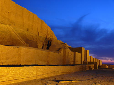
- Tchogha Zanbil
-
country : Iran, Islamic Republic of
location : Khuzestan
coordinate : N32 4 59.88, E48 31 60
Enrollment Year : 1979year
heritage area : 0ha
buffer zone : 0ha
- Standard
-
Standard(Ⅲ) :Standard(IV) :
- Summary(Ⅵ) : : The ruins of the holy city of the Kingdom of Elam, surrounded by three huge concentric walls, are found at Tchogha Zanbil. Founded c. 1250 B.C., the city remained unfinished after it was invaded by Ashurbanipal, as shown by the thousands of unused bricks left at the site.
-

-
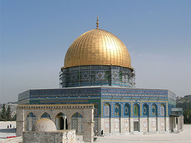
Old City of Jerusalem and its Walls
 ⓒUNESCO
- Old City of Jerusalem and its Walls
-
country : Jerusalem (Site proposed by Jordan)
location : Jerusalem District
coordinate : N31 46 60, E35 13 0
Enrollment Year : 1981year
heritage area : 0ha
buffer zone : 0ha
- Standard
- Summary(Ⅵ) : : As a holy city for Judaism, Christianity and Islam, Jerusalem has always been of great symbolic importance. Among its 220 historic monuments, the Dome of the Rock stands out: built in the 7th century, it is decorated with beautiful geometric and floral motifs. It is recognized by all three religions as the site of Abraham's sacrifice. The Wailing Wall delimits the quarters of the different religious communities, while the Resurrection rotunda in the Church of the Holy Sepulchre houses Christ's tomb.
-
-
 ⓒUNESCO
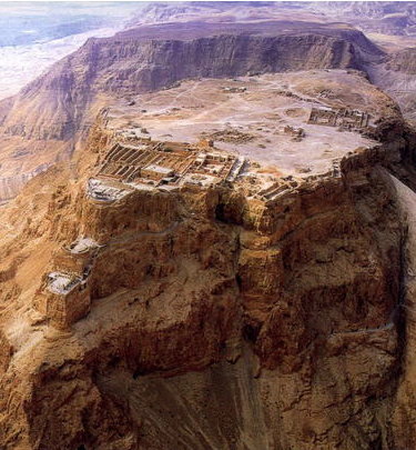
- Masada
-
country : Israel
location :
coordinate : N31 18 48.6, E35 21 9.9
Enrollment Year : 2001year
heritage area : 276ha
buffer zone : 0ha
- Standard
- Summary(Ⅵ) : : Masada is a rugged natural fortress, of majestic beauty, in the Judaean Desert overlooking the Dead Sea. It is a symbol of the ancient kingdom of Israel, its violent destruction and the last stand of Jewish patriots in the face of the Roman army, in 73 A.D. It was built as a palace complex, in the classic style of the early Roman Empire, by Herod the Great, King of Judaea, (reigned 37 – 4 B.C.). The camps, fortifications and attack ramp that encircle the monument constitute the most complete Roman siege works surviving to the present day.
-
-
 ⓒUNESCO
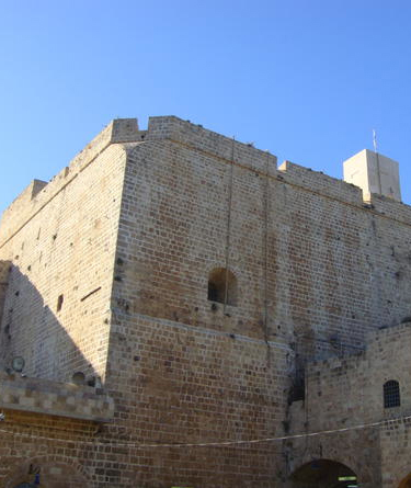
- Old City of Acre
-
country : Israel
location : Western Galilee
coordinate : N32 55 42, E35 5 2
Enrollment Year : 2001year
heritage area : 63ha
buffer zone : 0ha
- Standard
- Summary(Ⅵ) : : Acre is a historic walled port-city with continuous settlement from the Phoenician period. The present city is characteristic of a fortified town dating from the Ottoman 18th and 19th centuries, with typical urban components such as the citadel, mosques, khans and baths. The remains of the Crusader town, dating from 1104 to 1291, lie almost intact, both above and below today's street level, providing an exceptional picture of the layout and structures of the capital of the medieval Crusader kingdom of Jerusalem.
-
-
 ⓒUNESCO
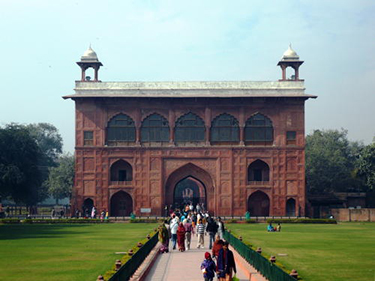
- Red Fort Complex
-
country : India
location : New Delhi State, Central District, New Delhi
coordinate : N28 39 20, E77 14 27
Enrollment Year : 2007year
heritage area : 49ha
buffer zone : 43ha
- Standard
- Summary(Ⅵ) : : The Red Fort Complex was built as the palace fort of Shahjahanabad – the new capital of the fifth Mughal Emperor of India, Shah Jahan. Named for its massive enclosing walls of red sandstone, it is adjacent to an older fort, the Salimgarh, built by Islam Shah Suri in 1546, with which it forms the Red Fort Complex. The private apartments consist of a row of pavilions connected by a continuous water channel, known as the Nahr-i-Behisht (Stream of Paradise). The Red Fort is considered to represent the zenith of Mughal creativity which, under the Shah Jahan, was brought to a new level of refinement. The planning of the palace is based on Islamic prototypes, but each pavilion reveals architectural elements typical of Mughal building, reflecting a fusion of Persian, Timurid and Hindu traditions The Red Fort’s innovative planning and architectural style, including the garden design, strongly influenced later buildings and gardens in Rajasthan, Delhi, Agra and further afield.
-
-
 ⓒUNESCO
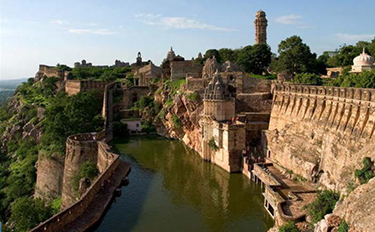
- Hill Forts of Rajasthan
-
country : India
location : Rajastahan
coordinate : N24 52 60, E74 38 46
Enrollment Year : 2013year
heritage area : 0ha
buffer zone : 0ha
- Standard
- Summary(Ⅵ) : : The serial site, situated in the state of Rajastahan, includes six majestic forts in Chittorgarh; Kumbhalgarh; Sawai Madhopur; Jhalawar; Jaipur, and Jaisalmer. The ecclectic architecture of the forts, some up to 20 kilometres in circumference, bears testimony to the power of the Rajput princely states that flourished in the region from the 8th to the 18th centuries. Enclosed within defensive walls are major urban centres, palaces, trading centres and other buildings including temples that often predate the fortifications within which developed an elaborate courtly culture that supported learning, music and the arts. Some of the urban centres enclosed in the fortifications have survived, as have many of the site's temples and other sacred buildings. The forts use the natural defenses offered by the landscape: hills, deserts, rivers, and dense forests. They also feature extensive water harvesting structures, largely still in use today.
-
-
 ⓒFederice Leone
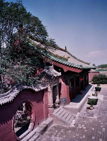
- Ancient City of Ping Yao
-
country : China
location : Ping Yao County, Shan Xi Province
coordinate : N37 12 5.004, E112 9 15.984
Enrollment Year : 1997year
heritage area : 0ha
buffer zone : 0ha
- Standard
- Summary(Ⅵ) : : Ping Yao is an exceptionally well-preserved example of a traditional Han Chinese city, founded in the 14th century. Its urban fabric shows the evolution of architectural styles and town planning in Imperial China over five centuries. Of special interest are the imposing buildings associated with banking, for which Ping Yao was the major centre for the whole of China in the 19th and early 20th centuries.
-
-
 ⓒUNESCO
- Site of Xanadu
-
country : China
location :
coordinate : N42 21 28.8, E116 11 6.46
Enrollment Year : 2012year
heritage area : 0ha
buffer zone : 0ha
- Standard
- Summary(Ⅵ) : : North of the Great Wall, the Site of Xanadu encompasses the remains of Kublai Khan’s legendary capital city, designed by the Mongol ruler’s Chinese advisor Liu Bingzhdong in 1256. Over a surface area of 25,000 ha, the site was a unique attempt to assimilate the nomadic Mongolian and Han Chinese cultures. From this base, Kublai Khan established the Yuan dynasty that ruled China over a century, extending its boundaries across Asia. The religious debate that took place here resulted in the dissemination of Tibetan Buddhism over north-east Asia, a cultural and religious tradition still practised in many areas today. The site was planned according to traditional Chinese feng shui in relation to the nearby mountains and river. It features the remains of the city, including temples, palaces, tombs, nomadic encampments and the Tiefan’gang Canal, along with other waterworks.
-
-
 ⓒUNESCO
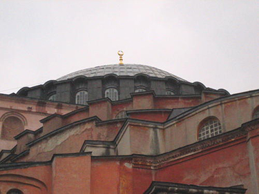
- Historic Areas of Istanbul
-
country : Turkey
location : City and Province of Istanbul
coordinate : N41 0 30.492, E28 58 47.748
Enrollment Year : 1985year
heritage area : 678ha
buffer zone : 0ha
- Standard
- Summary(Ⅵ) : : With its strategic location on the Bosphorus peninsula between the Balkans and Anatolia, the Black Sea and the Mediterranean, Istanbul has been associated with major political, religious and artistic events for more than 2,000 years. Its masterpieces include the ancient Hippodrome of Constantine, the 6th-century Hagia Sophia and the 16th-century Süleymaniye Mosque, all now under threat from population pressure, industrial pollution and uncontrolled urbanization.
-
-
 ⓒCRATerr-ENSAG
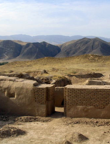
- Parthian Fortresses of Nisa
-
country : Turkmenistan
location : Bagyr settlement, Etrap of Rukhabad, Akhal Vilayet
coordinate : N37 59 59, E58 11 55
Enrollment Year : 2007year
heritage area : 78ha
buffer zone : 400ha
- Standard
- Summary(Ⅵ) : : The Parthian Fortresses of Nisa consist of two tells of Old and New Nisa, indicating the site of one of the earliest and most important cities of the Parthian Empire, a major power from the mid 3rd century BC to the 3rd century AD. They conserve the unexcavated remains of an ancient civilization which skilfully combined its own traditional cultural elements with those of the Hellenistic and Roman west. Archaeological excavations in two parts of the site have revealed richly decorated architecture, illustrative of domestic, state and religious functions. Situated at the crossroads of important commercial and strategic axes, this powerful empire formed a barrier to Roman expansion while serving as an important communication and trading centre between east and west, north and south.
-