- UNESCO World Heritage-listed city walls
-
source >
 World Heritage Center (English/French)|http://whc.unesco.org
Korean National Commission for UNESCO (translation supervision)|http://unesco.or.kr/heritage
America
-
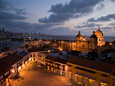
Port, Fortresses and Group of Monuments, Cartagena
 ⓒOUR PLACE
- Port, Fortresses and Group of Monuments, Cartagena
-
country : Colombia
location : Bolivar Department
coordinate : N10 25 0, W75 31 60
Enrollment Year : 1984year
heritage area : 0ha
buffer zone : 0ha
- Standard
-
Standard(IV) :Standard(Ⅵ) :
- Summary(Ⅵ) : : Situated in a bay in the Caribbean Sea, Cartagena has the most extensive fortifications in South America. A system of zones divides the city into three neighbourhoods: San Pedro, with the cathedral and many Andalusian-style palaces; San Diego, where merchants and the middle class lived; and Gethsemani, the 'popular quarter'.
-

-
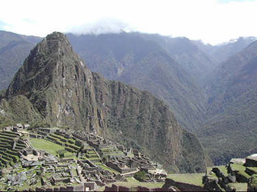
Historic Sanctuary of Machu Picchu
 ⓒUNESCO
- Historic Sanctuary of Machu Picchu
-
country : Peru
location :
coordinate : S13 7 0, W72 34 60
Enrollment Year : 1983year
heritage area : 32592ha
buffer zone : 0ha
- Standard
-
Standard(Ⅰ) :Standard(Ⅲ) :
- Summary(Ⅵ) : : Machu Picchu stands 2,430 m above sea-level, in the middle of a tropical mountain forest, in an extraordinarily beautiful setting. It was probably the most amazing urban creation of the Inca Empire at its height; its giant walls, terraces and ramps seem as if they have been cut naturally in the continuous rock escarpments. The natural setting, on the eastern slopes of the Andes, encompasses the upper Amazon basin with its rich diversity of flora and fauna.
-
-
 ⓒUNESCO
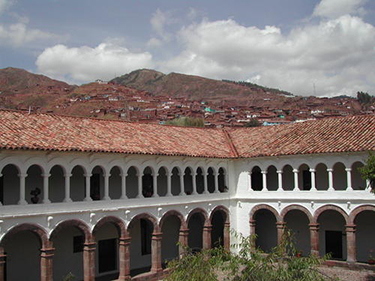
- City of Cuzco
-
country : Peru
location : City of Cuzco
coordinate : S13 31 19.992, W71 58 59.988
Enrollment Year : 1983year
heritage area : 0ha
buffer zone : 0ha
- Standard
-
Standard(Ⅲ) :Standard(IV) :
- Summary(Ⅵ) : : Situated in the Peruvian Andes, Cuzco developed, under the Inca ruler Pachacutec, into a complex urban centre with distinct religious and administrative functions. It was surrounded by clearly delineated areas for agricultural, artisan and industrial production. When the Spaniards conquered it in the 16th century, they preserved the basic structure but built Baroque churches and palaces over the ruins of the Inca city.
-
-
 ⓒUNESCO
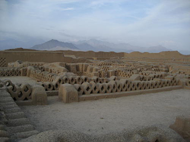
- Chan Chan Archaeological Zone
-
country : Peru
location : District of Huanchaco
coordinate : S8 5 60, W79 4 59.988
Enrollment Year : 1986year
heritage area : 600ha
buffer zone : 0ha
- Standard
-
Standard(Ⅰ) :Standard(Ⅲ) :
- Summary(Ⅵ) : : The Chimu Kingdom, with Chan Chan as its capital, reached its apogee in the 15th century, not long before falling to the Incas. The planning of this huge city, the largest in pre-Columbian America, reflects a strict political and social strategy, marked by the city's division into nine 'citadels' or 'palaces' forming autonomous units.
-
- 1