Hanyangdoseong|
Namsan(Mongmyeoksan) Mountain Trail
Home
Excursions Along The Wall
Namsan(Mongmyeoksan) Mountain Trail
- Jangchung Gymnasium ~ Baekbeom Square
- Distance: 4.2km / Away: about 3 hours
-
Difficulty
★★★
Namsan(Mongmyeoksan) Mountain Trail
Section : Jangchung Gymnasium ~ Baekbeom Square
Distance : 4.2km
Away : about 3 hours
This walking trail runs from the backstreets of Janchung Gymnasium to Namsan Park. In early Joseon, a national shrine and beacon platform were built near and at the top of Namsan (Mongmyeoksan, 270m). As Namsan was the center of the administrative district in Seoul, there is a stone marker inscribed with “the Central Point of Seoul” on the summit. In the 1920’s, most the wall in the area were demolished to build the Joseon Shinto Shrine by the Japanese; but due to the preservation and restoration projects conducted since the 1970s and the Namsan recovering project carried out in the mid-1990s, most of the wall sections around Namsan have been restored to their original appearance.
• Opening hours : Namsan – 24 hours
• Tip: Visitors are advised to check the event schedule of Namsangol Hanok Village, many interesting events are held there.
Transportation
[Namsangol Hanok Village] ❸ ❹ Chungmuro Station Exit 4 → 1 minute on foot
[Jangchungdan Park] ❸ Dongguk Univ. Station Exit 6 → 1 minute on foot
[Jangchung Gymnasium] ❸ Dongguk Univ. Station Exit 5 → 2 minutes on foot
[Namsan Park Bus Stop] Namsan Shuttle Bus No. 02, 03 or 05 → Get off at Namsan Park
[Namsan Public Library] Namsan Shuttle Bus No. 02, 03 or 05 → Get off at Namsan Public Library
[Baekbeom Square] ❹ Hoehyeon Station Exit 4 → 5 minutes on foot / ❹ Myeongdong Station Exit 3 → 10 minutes on foot
Section main points
-
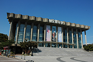
National Theater of Korea
The National Theater of Korea, a venue for live performances and the arts, was built in Jangchung-dong, Seoul in 1973. It is also the place where Yuk Young-soo (the first lady of the former Korean president Park Chung-hee, was assassinated on South Korean Independence Day in 1974. The theater comprises of the Main Hall Hae, Dal (small hall), Studio Byeol, and Haneul Youth Theater (amphitheater) facilities.
-
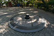
Central Point of Seoul
Where is the central point of Seoul? The result of a GPS measurement confirmed that the geographical central point of Seoul is on the top of Namsan, where a stone marker bearing the inscription “Central Point of Seoul” was erected.
-
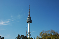
N Seoul Tower
- The N Seoul Tower is an observation tower located on the summit of Namsan. Rising 480m above sea level, the tower is inarguably Seoul’s most popular attraction, offering a 360° view of the city. The tower was originally built in 1969 for telecommunications and broadcasting, including television and radio, and has been open to the public since 1980. After extensive renovations in 2005, the Tower was reopened as a complex cultural space. Various stories about Hanyangdoseong are displayed on the second floor of the Tower Observatory.
- • Opening Hours : N Seoul Tower Observatory - Monday~Friday / Sunday 10:00~23:00 | Saturday 10:00~24:00
- ※The second floor (T2) of the N Seoul Tower Observatory displays various stories about the Hanyangdoseong.
* Opening Hours of Namsan Cable Car : 10a.m.~11p.m. (The cable car service may be opened one hour longer than the normal opening hours on Fridays, Saturdays, and days before National Holidays depending on the circumstances.)
-
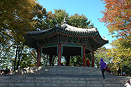
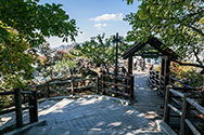
Namsan Palgakjeong Pavillion and Site of Guksadang Shrine
Namsan Palgakjeong was built at Site of Guksadang of Joseon. In 1925, when the Japanese built the Shinto Shrine, Guksadang was moved to the foot of Inwangsan Mountain. During the First Republic of South Korea, the pavilion, which was modeled on Palgakjeong in Tapgol Park at this site, was named “Unamjeong” after the pen-name of the then President Syngman Rhee, but it was renamed Palgakjeong after the April 19 Revolution.
-
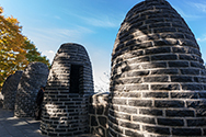
Site of Mongmyeoksan Beacon Mound
Site of Mongmyeoksan Beacon Mound was the final destination for beacon signals sent from the border areas during Joseon. In the daytime, smoke was used to transmit messages, while at night a signal fire was lit. This beacon platform was built in 1423 and survived intact for over 450 years until 1895. The current mound was restored in 1993.
-
Jamdubong Photo Island
The western summit of Namsan called Jamdubong (“Silkworm Head Peak”) because of its shape. The observatory platform on Jamdubong commands a panoramic view of the city, which looks like a dense forest of buildings surrounded by the four inner mountains.
-
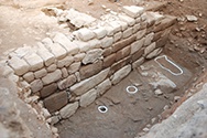
Remains of the wall at the foot of Hoehyeon, Namsan
The area around the Patriot Ahn Jung-geun Memorial Hall on Namsan was damaged during the construction of the Shinto in 1925. In 2013, when the Seoul Metropolitan Government implemented a project for the preservation and maintenance of Hanyangdoseong, parts of the base of the wall were unearthed in good condition in this area.