Hanyangdoseong|
Naksan Mountain Trail
Home
Excursions Along The Wall
Naksan Mountain Trail
- Hyehwamun Gate ~ Heunginjimun Gate
- Distance: 2.1km / Away: about 1 hour
-
Difficulty
★★
Naksan Mountain Trail
Section : Hyehwamun Gate ~ Heunginjimun Gate
Distance : 2.1km
Away : about 1 hour
This hiking trail runs from Hyehwamun to Heunginjimun, passing via Naksan (124m), the lowest mountain of Seoul’s four inner mountains. Naksan is also known as Naktasan (“Camel Mountain”) or Tarak, due to its resemblance to a camel’s humps. This course is relatively easy due to its gentle slope. Alert visitors will notice the different shapes of the stones depending on the time of construction of the wall, as they walk along the path behind the Catholic Univ. of Korea.
• Opening hours : 24 hours
• Notice : Visitors are recommended to be silent for the residents of Bukjeong Village.
Transportation
[Entrance to Naksan] ❹ Hansung Univ. Station Exit 4 → 3 minutes on foot / ❹ Hyehwa Station Exit 1 → 5 minutes on foot
[Top of Naksan Park] ❹ Hyehwa Station Exit 2 → 15 minutes on foot / ❶❹ Dongdaemun Station Exit 5 → Jongno Town Bus No. 03 → Get off at Naksan Junction
[Naksan Park / Ihwa Village] ❹ Hyehwa Station Exit 2 → 20 minutes on foot
[Dongdaemun Seonggwak Park] ❶❹ Dongdaemun Station Exit 10 → 2 minutes on foot
Section main points
-
Jangsu Village
Situated next to the wall in the southeast of Naksan Park, Jangsu Village originally formed as a shantytown after the Korean War, and was named Jangsu(longevity) Village as the majority of the population was over 60 years old. When the village was designated as a redevelopment area due to its narrow alleys and old buildings, the inhabitants managed to halt the redevelopment project, and a village regeneration project was carried out instead. Jangsu Village is considered a successful case of a village regeneration project being conducted with residents’ participation.
-
Naksan Park
Naksan Park (Playground) is situated inside the wall, and can be reached from Jangsu Village via the Ammun (Secret Path). Naksan Park, which is also known as the Montmartre of Seoul, offers visitors great views of the city, including splendid views of the sunset and Seoul at night.
-
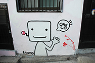
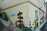
Ihwa Village
Ihwa Village, just inside the wall on the Naksan Trail, was established many years ago. It used to be regarded as an area that had fallen behind in Seoul, but since 2006, with the government’s support, artists have colorful murals on the walls of the buildings and installed sculptures here and there, giving the community a bright and cheerful atmosphere. From the end of the stairway at the top of Naksan, walkers can see the wall, which encloses Ihwa Village.
-
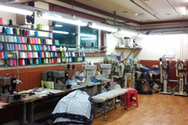
Sewing Village in Changsin-dong (Site of Quarry)
During the Joseon, retired court ladies lived in Changsin-dong outside the Naksan section of the wall. After 1960, the area became a center of the apparel industry as subcontractors who made clothing gathered from Dongdaemun Market. There is the steep rocky cliff (40m in height, 201m in width) in the town that was used as a quarry from the Daehan Empire to the Japanese Colonial Period. Now, the area is packed with houses, even on the cliff.
-
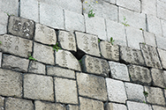
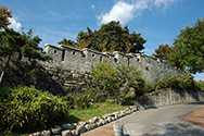
Real-name construction system and inscribed stone blocks
Some of the stone blocks used to build the wall have characters inscribed in them. Such stones are most commonly found around the section of the wall next to Dongdaemun Seonggwak Park, where they were collected and put together during the wall maintenance project. In the reigns of Kings Taejo and Sejong, the stones were inscribed with the names of the county and prefecture responsible for constructing a given wall section, as well as the name of that section, while in the mid-Joseon, they were marked with the names of the supervisors and lead technicians, and the construction date. The inscribed stone blocks in the photo on the right can be seen outside the wall, at the end section of the Naksan Trail.
-
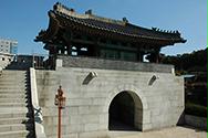
Hyehwamun Gate
It is Dongbukmun (Northeast Gate), one of the four auxiliary gates on the wall. It was originally called Honghwamun at the time of its construction in 1396, but was renamed as Hyehwamun in 1511. The gate tower was demolished in 1928, followed by Hongye(halfarched door) in 1938. However, Hyehwamun was reconstructed in its current location, a little further north from its original site, in 1994.
-
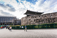
Heunginjimun Gate
Heunginjimun is “East Gate” (Dongdaemun) of the wall. The current Heunginjimun was rebuilt in the sixth year of the reign of Emperor Gojong (1869). Regarding the topography of Seoul, the western part of the city is built on higher ground, while the eastern part is on low ground, so from a military perspective, Dongdaemun was the most vulnerable to attack. That is why the subsidiary wall were built outside Dongdaemun. In 1907, the walls on the right and left sides of the gate were demolished.